Dyrhólaey headland and nature reserve
A 120 m promontory west of Vík with a lava arch 50 m wide, a small lighthouse from 1927 and puffin cliffs. Parts of it close in the nesting season, and the upper road often shuts in winter.
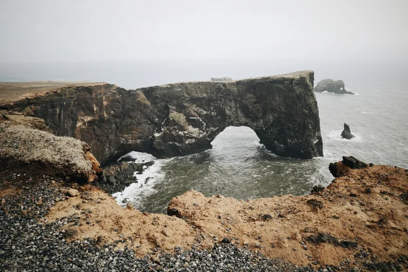
Visit South Iceland describes Dyrhólaey as a 120 m high promontory not far from Vík. It lies just west of Reynisfjara, with the small closed beach of Kirkjufjara at its foot. The Environment Agency of Iceland explains its origin: a tuya formed in at least two eruptions around 100,000 years ago.
The headland has two parts. Háey, the higher western section, came from an eruption under the sea. Lágey, the lower eastern part, is built of tuff, pillow lava and columnar basalt. The name, roughly "the island with the door hole", comes from the lava arch at its tip, about 20 m high and 50 m wide.
The lighthouse and the upper area
The turn-off from Route 1 is signposted about 5 km west of Vík, and a gravel road leads in. There are two car parks: a lower one near the beach, with toilets in summer, and an upper one by the lighthouse, about 1.3 km apart on foot with a steady climb.
On Háey stands Dyrhólaeyjarviti, a small square lighthouse with an orange roof, built in 1927. The last part of the road up is steep, narrow and rough in places. In summer an ordinary car manages it if you drive slowly. In winter the upper road is often closed entirely because of ice and wind.
The lower area, by the viewpoint over the arch, is usually reachable when the upper road is shut. The path between Lágey and Háey has been moved back from the edge because of cracks in the ground, and the barriers along the cliffs are there for the same reason.
Nesting season closures
Dyrhólaey has been a nature reserve since 1978. The municipality of Mýrdalshreppur looks after land protection under a management agreement made with the Environment Agency, and it provides a ranger during the nesting season. The rules allow the authority to restrict visits between 1 May and 25 June. Since January 2025 the Environment Agency's work on protected areas has passed to Náttúruverndarstofnun, the new state agency for nature conservation. Each year an ornithologist assesses whether, and how far, the headland is closed.
In practice, Visit South Iceland wrote in May 2026, parts of Dyrhólaey close every spring, usually from around mid-May to late June. During that time both areas are open daily from 9:00 to 19:00, the upper area around the lighthouse closes completely overnight, and the lower area by the arch mostly stays open, sometimes with shorter hours. The exact dates change, so check the signs on site.
Puffins and other birds
Puffins nest in the cliffs from late April to mid-August, so a visit between May and early August gives the best chance, within the nesting-season opening hours. The management plan also lists fulmars and eiders, and among the rarer species the short-eared owl, the pintail, the goosander and the white-tailed eagle.
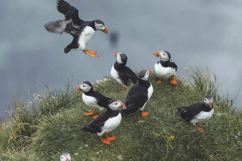
The birds sit close to the grassy edges, and so do the cracks. Stay behind the ropes even if the view looks better a step further out. Families with children will find advice for this stretch of coast on our Vík with kids page.
Rules in the reserve
The reserve covers roughly 150 hectares. Its management plan from 2014 ran until 2023, so details of the rules may change with the next one. The plan also covers the use rights for eider ducks on the headland. Driving off the roads is forbidden, and camping needs a permit. Riding through the reserve is allowed, but horses may not graze freely, and livestock grazing before 25 June is not permitted. Parking is charged, and the PARKA app is the suggested way to pay.
Below the headland, the small beach Kirkjufjara has been closed to visitors since rock falls and accidents at sea between 2012 and 2017. The beach you can visit nearby is Reynisfjara; read about its warning lights on our Reynisfjara page before you go down to the water.
In winter the headland is quieter. The lower area by the arch is often the only part you can reach by car, and in December the sun is up for under five hours, so plan a visit around midday.
Seeing Dyrhólaey from the sands
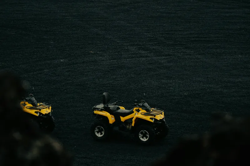
No guided tour goes onto the headland, but the quad safari from the Icelandic Mountain Guides base near Vík rides the black sand plains of Sólheimasandur, stops at the DC-3 plane wreck from 1973 and follows the coast with a view of Dyrhólaey before returning along the Jökulsá river. It takes one or two hours, drivers need a valid licence, and children under 8 cannot ride.
Reviews mention large groups and waiting time between sections, and solo riders are surprised to need a single-rider booking. Other ways onto the sands are compared on our ATV and buggy tours page. Before driving up in winter, check road conditions on umferdin.is or by phone on 1777.
All tours side by side
There is no guided tour onto the headland itself. This quad safari rides the black sand plains nearby and stops on the coast with a view across to Dyrhólaey.
| Tour | Format | Duration | Age | Rating | From |
|---|---|---|---|---|---|
| Quad bikes on SólheimasandurIcelandic Mountain GuidesYou ride across the black sand of Sólheimasandur with a stop at the 1973 DC-3 wreck, then to the coast facing Dyrhólaey and through a river into a valley. | Self-drive quad, licence neededInsulated overall, helmet, balaclava, coffee and tea | 1 or 2 hoursIcelandic Mountain Guides base off Road 222 | From 8 years; drivers need a licence | 4.9 (541 reviews) | From €138Free cancellationBook on GetYourGuide |
Prices and ratings come from the booking platform and are shown in euros per person. If you book through these links we earn a commission. Your price stays the same. Sorted by number of reviews.
Questions travellers ask
Is Dyrhólaey closed in May and June?
Partly. The nature conservation authority may restrict visits from 1 May to 25 June each year while birds nest. Visit South Iceland describes the usual practice as both areas open from 9:00 to 19:00 in that period, with the upper area around the lighthouse closed at night.
Can I drive up to the lighthouse?
In summer an ordinary car is fine if you take the steep, narrow last stretch slowly. In winter the upper road is often closed completely because of ice and wind, and then only the lower area by the arch is reachable.
When can I see puffins at Dyrhólaey?
From late April to mid-August, when they nest in the cliffs. Keep behind the barriers and away from the edges, which are cracked in places.
Can I walk down to Kirkjufjara beach?
No. Access to Kirkjufjara below the headland has been prohibited since rock falls and accidents at sea between 2012 and 2017.
Do I have to pay for parking?
Yes. Parking at Dyrhólaey is charged, and Visit South Iceland recommends paying with the PARKA app.
Where these facts come from
Dates, opening hours and rules change. We checked these pages in October 2026; the official source has the final word.
- Visit South Iceland: Visiting Dyrhólaey, what to know before you go (20 May 2026)
- Umhverfisstofnun: Dyrhólaey, about the island
- Umhverfisstofnun: Dyrhólaey, access and management
- Umhverfisstofnun: Dyrhólaey management and protection plan 2014–2023 (PDF, Icelandic)
- Lög um Náttúruverndarstofnun nr. 111/2024 (Stjórnartíðindi, Icelandic)
- Visit South Iceland: Top destinations
- Umferdin (Road and Coastal Administration): road conditions
- Tour pages on GetYourGuide and Viator, checked 23 October 2026